
Afrasiant - The E1 plan has been transformed from a settlement project into a tool to re-"demarcate" Jerusalem and the West Bank, and to impose a political and geographical reality that paves the way for the end of the "dream of a Palestinian state." How is Palestine re-engineered today?
Jerusalem and the West Bank occupy a central strategic position in the history of the Israeli occupation of Palestine, not only in terms of religion and symbolism, but also as the vital field in which the contours of sovereignty and national identity are determined. In this context, the E1 project, or the so-called "East Gate of Jerusalem," represents a pivotal point in an Israeli strategy aimed at tightening control over the city and expanding the surrounding settlement network.
E1 is not seen as mere urban expansion, but as an integrated strategic plan that combines the fortification of Jerusalem, the separation of the north and south of the West Bank, and the prevention of the establishment of a geographically contiguous Palestinian state. The project integrates dual infrastructure, bypass roads, and tunnels, to reshape Palestinian geography and transform it into a space under Israeli control, thus enshrining geographical separation and dual sovereignty over the land.
This report aims to provide an in-depth analysis of the E1 plan within the "Greater Jerusalem Project", in terms of geographical and political dimensions, humanitarian repercussions, and international positions, to shed light on the crucial role that this eastern gate plays in shaping Israeli control over Jerusalem and the West Bank.
E1: The Strategic Corridor to Close the Horizon of the Palestinian State and Consecrate "Greater Jerusalem"
In Israel's geopolitical vision, the E1 project is not viewed as a limited urban expansion, but rather as the "eastern gate" of Jerusalem, and a critical corridor in redefining the city's borders and strategic function.
In this context, mapping and settlement expert Khalil al-Tafakji, in an interview with Al-Mayadeen Net, explains the deep dimensions of the plan, stressing that it carries a number of overlapping strategic goals.
The first goal, according to al-Tafakji, is to consolidate the "Greater Jerusalem" project by surrounding the Old City from the eastern side with an intensive settlement cordon, in a way that consolidates the concept of "protecting the capital" according to the Israeli vision, and reshapes the urban and demographic space surrounding it.
The second goal is to prevent the establishment of a Palestinian state with East Jerusalem as its capital, by controlling the open zone, which is the only possible geographical extension to connect Jerusalem to its Palestinian surroundings. In doing so, it virtually eliminates any perception of Palestinian sovereignty in the city.
The third goal is to separate the north of the West Bank from its south, by laying a settlement corridor that extends from the vicinity of Jerusalem east to the Jordan Valley. This extension not only achieves geographical separation, but also connects the settlement bloc in Ma'ale Adumim to the eastern depth, all the way to the Jordan Valley, within a vision that goes beyond the present to long-term plans until 2050.
These facts highlight the complex nature of the project: it is both a tool for security fortification, a mechanism for geographical separation, and a platform for redefining the function of Jerusalem within the concept of "Greater Jerusalem" extending eastward. In this sense, E1's function is not limited to connecting Ma'ale Adumim to Jerusalem, but also to establish a strategic corridor connected from the coast to the Jordan Valley, reshaping the political map and turning the Palestinian presence into scattered pockets within a space dominated by the settlement structure.
Al-Tafakji adds a planning-future dimension that goes beyond the residential framework, pointing out that Israel's long-term vision includes the establishment of an airport in the Nabi Musa area, with a large capacity that may reach tens of millions of travelers and tourists annually, as part of a comprehensive restructuring of the space between Jerusalem and the Jordan Valley.
These projects, along with the so-called "Sovereignty" Street (officially presented as part of the "Fabric of Life" project), are part of a policy aimed at regionally linking this eastern extension and strengthening Israeli control over it as a vital area open to the border with Jordan.
In this sense, E1 is not a phased plan, but rather a central link in a long-term strategic project that redefines the geopolitics of Jerusalem and the West Bank through infrastructure and settlements.
"Ma'ale Adumim" and "Greater Jerusalem": The Cornerstone of the Redrawing of Geography in East Jerusalem
The settlement of Ma'ale Adumim is one of the most dangerous and largest Israeli settlement projects in the West Bank, not only because of its size and number of settlers, but also because of its strategic role in reshaping the geopolitics of Jerusalem and the West Bank.
The settlement began as a small outpost in 1975 with about 15 ideological settlers, before gradually turning into a large-scale project, and received the status of a "city" in 1991, becoming the first settlement in the West Bank to be granted this classification, in a step with political and legal dimensions aimed at normalizing its existence and administratively integrating it into the Israeli space.
The first government of Menachem Begin (1977–1981) undertook the structural planning of the settlement as part of a vision aimed at penetrating the geographical depth of the West Bank and tightening the settlement cordon around "East Jerusalem". In 1979, the government approved a plan to demarcate its borders on an area of approximately 3,500 hectares, on which some 2,600 housing units were built in its early stages.
Contrary to the official Israeli narrative, the settlement was established on land owned by neighboring Palestinian villages such as Abu Dis, al-Eizariya, Anata, al-Tur, and Issawiya, and was accompanied by extensive confiscations and forced displacement of Bedouin communities.
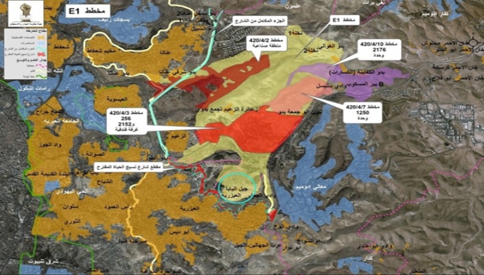
In an interview with Al-Mayadeen Net, researcher and specialist in Jewish studies, Fawzi al-Badawi, stresses that understanding the role of Ma'ale Adumim is not complete without stopping at the E1 project, which he describes as "one of the most dangerous colonial projects targeting Jerusalem, not only as an urban expansion, but also as the central geographical pillar of the Greater Jerusalem project." He explains that this project is officially marketed as a "developmental" plan for an area extending over about 12 square kilometers east of Jerusalem, and includes the construction of about 3,400 settlement housing units, infrastructure, roads and service networks, but its strategic goal is to achieve full geographical connectivity between "Ma'ale Adumim" and occupied Jerusalem.
According to al-Badawi, this linkage will transform the settlement, which is currently home to about 40,000 settlers, about 70% of whom work in Jerusalem, into a direct urban and economic extension of the city, which means effectively annexing it to the large settlement bloc and imposing a Jewish urban contiguity in East Jerusalem. He believes that this step is part of a broader vision to re-engineer the demographics of the city and its surroundings, with the aim of consolidating a Jewish majority of about 70% by 2030, in exchange for reducing the Palestinian presence and turning it into isolated and besieged enclaves.
According to Al-Badawi, the repercussions of this project are not limited to the borders of Jerusalem, but extend to the entire Palestinian geography in the West Bank, as the implementation of the E1 plan severs the geographical connection between the north and south of the West Bank, and turns Palestinian cities and communities into separate "cantons" linked to a network of bypass roads that are fully under Israeli security control. The project also constitutes a suffocating settlement ring around East Jerusalem, isolating it from its natural surroundings and preventing any possibility of its future Palestinian urban or demographic expansion.
Politically, Al-Badawi stresses that the E1 project represents a severe blow to the possibility of the establishment of a geographically connected and viable Palestinian state, as it practically undermines the principle of Jerusalem as the capital of the Palestinian state, and cuts off one of the most important vital communication axes between Ramallah and Bethlehem through the city. In his opinion, this path reflects a clear shift in the Israeli strategy from managing the conflict to resolving it on the ground by imposing geographical realities that are difficult to reverse in any future negotiation process.
He adds that the centrality of Jerusalem in this project goes beyond the political dimension, as it has been presented in the Zionist discourse as the heart of the Zionist project and the essence of what is known as the "Promised Land", a term that has been used and reproduced politically to provide religious cover for annexation and settlement projects, despite the fact that it is not mentioned verbatim in this form in the biblical text.
Ultimately, Ma'ale Adumim cannot be seen as an ordinary settlement, but rather as a cornerstone of the Greater Jerusalem project, which seeks to redraw the political and demographic map of the region. With the planned connection via E1, the settlement becomes a critical tool to entrench Jewish demographic supremacy, isolate East Jerusalem, and undermine any possibility of a geographically contiguous Palestinian state, in clear contradiction to the norms of international law and resolutions of international legitimacy that affirm the illegality of the settlement and reject any change in the legal status of occupied Jerusalem.
Sovereignty Street and Dual Infrastructure: Separation Engineering Instead of Making Life Easier
In his field reading of the "Fabric of Life" project, which is officially marketed today under the name of "Sovereignty" Street, Khalil al-Tafakji provides an accurate description of his real job, far from the discourse that he promotes as a project to improve traffic.
Al-Tafakji says that the road being built effectively leads to the creation of two separate infrastructures: one for Palestinians and one for Israelis, so that the Palestinian side is not allowed to use the infrastructure intended for Israelis. The route of the street starts in the Azaria area, at a time when the main road leading to the settlement of Ma'ale Adumim is expected to be closed to Palestinians, so that their traffic through this alternative route is redirected towards Jericho. According to this plan, any Palestinian coming from the south to the north of the West Bank would be forced to take this road, passing through tunnels and streets completely separated from the Israeli road network, and all the way to Ramallah.
These data reveal that the project is not a neutral traffic intervention, but rather an integrated system of racial segregation. Instead of being a connecting tool, infrastructure is being employed to produce isolated Palestinian paths that pass through tunnels and bypass roads, while keeping the main settler network open, connected, and under direct control. Urban planning thus becomes a tool for reproducing the geographical separation at the level of daily life, thereby entrenching a duality of infrastructure and sovereignty.
Al-Tafakji adds another dimension related to the reordering of the Israeli movement, pointing out that the removal of the Al-Zaim checkpoint aims to facilitate the movement of settlers between the settlement of "Ma'ale Adumim" and "West Jerusalem". He believes that this step comes within a broader policy that does not aim at the establishment of a Palestinian state, but rather seeks to surround Palestinian communities with a network of Israeli streets and settlements, in a way that makes them easier to control, especially at the eastern gate of Jerusalem.
The removal of barriers to settlers, in exchange for the tightening of alternative routes imposed on Palestinians, confirms that the goal is not to "facilitate movement" but rather to redistribute them according to a discriminatory sovereign logic.
The plan ensures the smooth flow of the settlement expansion from Jerusalem to Ma'ale Adumim, in exchange for encircling Palestinian communities and subjecting them to a controlled movement system. Displacement of Bedouin communities and redrawing the vital area.
This project is inseparable from a broader context that aims to reshape the vital area east of Jerusalem, by pressuring the Bedouin communities to leave, thus opening the way for the completion of the settlement belt and the connection of the major blocs to each other.
In this way, "Sovereignty" Street becomes part of an integrated system that re-engineers geography and demography together, under the guise of infrastructure, while its essence is to redraw the actual boundaries of sovereignty on the land.
E1 and the Battle of the Earth: Between Geography and Human Displacement
Geographically, E1 is the narrowest point in the West Bank, with only about 28 kilometers (28 kilometers) from east to west. The danger of settlement construction in this area is that it threatens to almost completely cut off the geographical connection between the north and south of the West Bank, and to turn Palestinian cities into separate cantons, connecting each other through Israeli-controlled bypass roads.
The implementation of the plan also leads to the complete isolation of East Jerusalem from its Palestinian extension, and deprives it of its economic, religious and cultural depth, so that access to it becomes a matter of security clearances subject to Israeli political discretion.
The humanitarian dimensions are just as serious as the geographical repercussions. The E1 area has become the scene of repeated forced displacements, targeting Bedouin communities, especially the Jahalin tribe, which has been uprooted from its land since the 1980s and moved to marginal areas near landfills.
It is estimated that the full implementation of the plan could lead to the displacement of more than 1,000 Palestinians from the remaining Bedouin communities east of Jerusalem, in clear violation of international humanitarian law, which prohibits the forcible transfer of the population under the Occupation.
Ultimately, E1 is not just a buildable space, but a strategic tool for resolving the conflict over Jerusalem and the West Bank through urban planning and settlements. The plan, if implemented, means undermining any possibility of a geographically contiguous Palestinian state, and consolidating the reality of de facto annexation, where borders are demarcated with asphalt and infrastructure before they are declared by legal texts.
In his description of the immediate impact on the ground, Khalil al-Tafakji emphasizes that E1 is not an "empty land," but rather a space that has witnessed systematic uprooting. He points out that the area of the plan, which is about 12 square kilometers, was accompanied by the removal of Palestinian communities extending from east Jerusalem to the Jordan Valley, in addition to the establishment of more than eight settlement pastoral outposts to harass the Bedouin communities and push them to leave.
He also explains that the plan cuts off the geographical connection between the south and the north and makes it slow and intermittent; the Palestinian coming from Hebron or Beit Meat towards Jericho will have to take longer and more complex routes, exacerbating transportation crises and congestion and turning daily traffic into a permanent burden.
Al-Tafakji places all of this within a broader vision that goes beyond residential or economic considerations, to fall within the framework of a security-geopolitical doctrine that considers the encirclement of Jerusalem by a settlement encirclement to be a strategic necessity. After 1967, successive settlement circles were built around the city to fortify it from the Eastern Front, based on a perception that the fall of the "capital" means the fall of the "state." In this sense, the settlement in E1 is transformingIt has become a geopolitical defense tool in the Israeli vision, and it has adopted its circles to secure full control over the area extending to the Jordan Valley, and to redraw the political map through realities on the ground that are difficult to reverse.
Historical Roots: From Herzl and Ben-Gurion to Netanyahu and Smotrich
Since the inception of the Zionist movement in the late nineteenth century, Jerusalem and the West Bank have not been an emergency negotiating topic, but have constituted the essence and ultimate horizon of the Zionist colonial project.
Theodor Herzl, the founder of political Zionism, wrote in his diary in 1897: "It was in Basel that the Jewish state was founded. And maybe in fifty years everyone will recognize it," an early reference to a project that transcends existing reality and is based on its imposition by force and time. In his book The Jewish State (1896), Herzl asserted that control of the land should be built gradually through settlement, not by waiting for political recognition.
Although Jerusalem was not under Zionist control at the time, it was present as the symbolic heart of the project, especially in the religious-nationalist discourse that accompanied Zionism from its earliest days.
With the British Mandate, Zionism moved from idea to implementation, and a more explicit discourse on the land emerged. In 1937, David Ben-Gurion, commenting on the Peel Commission, said, "We accept partition as a first stage, but the borders of the Zionist state will not be final." This statement clearly reflects the Zionist doctrine based on phased fragmentation and subsequent expansion. After the 1948 Nakba, despite the fact that East Jerusalem and the West Bank remained outside Israeli control, Ben-Gurion continued to assert that the armistice lines were not permanent political borders, but rather A temporary reality, which was later embodied in the 1967 war.
The occupation of East Jerusalem and the West Bank in 1967 was a pivotal moment in Zionist history, as the ideological dream turned into a possibility on the ground. In this context, Moshe Dayan said immediately after the war, "We have returned to Jerusalem and we will never leave it," in a political-ideological declaration that excludes the city from any negotiating framework. From that moment, the policy of imposing sovereignty through settlements began, as Yigal Allon considered control of the Jordan Valley and "Greater Jerusalem" a security and existential condition for Israel. This led to the formulation of the "Allon Plan," which laid the geographical foundations for the dismemberment of the West Bank.
With the rise of the Likud to power in 1977, the Zionist project entered a more explicit and less equivocal phase. Prime Minister Menachem Begin declared that "the right of the Jewish people to Judea and Samaria is a historic and eternal right," a rhetoric that removed the last barriers between ideology and executive policy. In the same context, Ariel Sharon, the architect of the settlements in the 1980s, said, "We must settle on every hill, because what we don't take today will be taken by the Palestinians tomorrow."
This doctrine formed the practical basis for the expansion of the major settlements, especially Ma'ale Adumim, which were designed from the outset to penetrate deep into the West Bank and connect it to Jerusalem.
In the 1990s, despite the Oslo process, this vision did not stop, but was reproduced with softer tools. Prime Minister Yitzhak Rabin said in 1995, before his assassination, that "we will establish a Palestinian entity less than a state," stressing that Jerusalem would remain "united under Israeli sovereignty." In this context, the comprehensive plan for the E1 area was approved in 1999, at a pivotal moment aimed at consolidating the geographical connection between Jerusalem and Ma'ale Adumim, beyond any declared political commitment.
At the current stage, the Zionist discourse has reached its peak in candor. Prime Minister Benjamin Netanyahu said in 2023, "The Jewish people have an exclusive and indisputable right to all of the Land of Israel." In August 2025, Finance Minister Bezalel Smotrich declared that "the implementation of the E1 plan buries the idea of a Palestinian state," in direct recognition that what is being implemented today is a practical translation of a historical doctrine that is more than a century old.
Thus, the time series is clear: From Herzl and Ben-Gurion, to Begin and Sharon, to Netanyahu and Smotrich, Jerusalem and the West Bank have remained at the heart of the Zionist project, as land to be controlled, not negotiated.
In this sense, the current policies from "Greater Jerusalem" to E1 do not represent a deviation from Zionist thought, but rather the culmination of its historical development, as it complements the goals set more than a hundred years ago, through the tools of planning and settlement instead of direct war, and in a way that makes the conflict over Jerusalem and the West Bank an existential struggle over land, narrative and sovereignty, not just a "border dispute" that can be resolved.
Analytical Conclusion
The joint approach of Khalil al-Tafakji and Fawzi al-Badawi shows that the E1 project cannot be read as an ordinary settlement expansion or an additional link in a series of urban projects, but rather as the crucial articulation of the "Greater Jerusalem" project and its most prominent strategic bet.
The plan combines three interrelated goals that form the core of Israel's vision for East Jerusalem:
First, fortify Jerusalem by encircling it with a settlement cordon from the eastern side, consolidating its control and redefining its de facto borders.
Second, undermine the possibility of a Palestinian state with East Jerusalem as its capital, by controlling the open space that represents the city's vital geographical expansion.
Third, the northern and southern West Bank were separated by a continuous settlement corridor that extends to the Jordan Valley, reshaping the geographical and political map of the West Bank.
In this context, bypass roads, tunnels, and dual infrastructure do not appear to be mere service projects, but solid tools for re-engineering the Palestinian vital sphere according to the logic of permanent control. Geography here is not managed as a neutral space, but rather as a political tool to produce a reality that is difficult to retract.
The E1 project is understood as the culmination of a long settlement process that seeks to resolve the conflict over Jerusalem and the West Bank through urban planning and the imposition of facts on the ground, rather than through traditional negotiation tracks.