
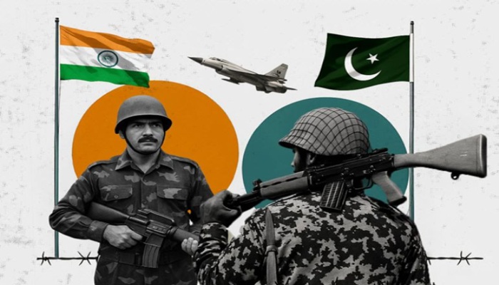
"Blood and water can't flow together." Indian Prime Minister Narendra Modi.
Afrasianet - Shadi Ibrahim - A few months after the end of World War II, British lawyer Cyril Radcliffe sat in his office ready to take up his duties in Britain's Public Prosecution, after completing his country's service in the World War as director of information management. The man had never traveled anywhere east of Paris as he was later known, but in a hurry as it seemed, London decided in 1947 to send him to the far East, where its colony was located. The largest to gain independence then: India. However, the news of independence brought the news of the bloody partition into two countries, India andPakistan.
The British lawyer was entrusted with the management of the Commission for the Demarcation of the Boundaries between the Republics of India and Pakistan at the time of their independence, and the man was given only about seven weeks' notice. The man knew nothing about India or Asia as a whole, but that was precisely the British excuse for sending him, as he knew nothing about the parties to the conflict, so he could be neutral enough, or so the British thought. "If Muhammad Ali Jinnah is responsible for the birth of Pakistan, Cyril Radcliffe is responsible for the strange geography it enjoyed," said Carl Schmidt, a professor of history and politics at the University of South Dakota in the United States, describing the current border between the two countries in a book on the history of South Asia.
The Radcliffe Line, as it is known, remains the separator between the two nuclear-armed states, divided not only by the Indian peninsula, but also by the historic state of Punjab, or five-river as its name appears to those who know Hindi or Persian (Bing means five and August means water). From here, water flows from India, which has a privileged position as an upstream country, towards Pakistan as a downstream country, through the rivers Gelum, Chenab, Rafi, Bias and Sutluj, all of which are branched off from The famous main Indus River.
Now India is taking advantage of the status quo to advance its political interests and refuse to recognize treaties governing the distribution of water from their shared rivers, threatening to spark a conflict between the two nuclear powers that could spread to the entire region. In this context, China is emerging as a major player in the India-Pakistan conflict, taking advantage of the chill in India-Pakistan relations to consolidate its influence and assert its presence in the region, where border tensions are increasing between it and India near the headwaters of rivers in the mountains. Himalayas, complicating the map of conflict between the two countries.
In the midst of these political and economic repercussions, Afghanistan may find itself forced to enter into this water conflict in search of expected development, and take serious steps towards it to compensate for years of war with America, NATO and before them the Soviet Union. While the rivers of politics and geography intersect in that part of Asia, generously flowing to irrigate its lands and feed its civilizations, at a moment it could turn into wild waters that fuel the world's most dangerous conflicts.
Indus Water Treaty in Wind
The Indus River is one of the main sources of water in Pakistan, with up to 65% of Pakistan's agricultural land irrigated by its water, and agricultural land irrigated from the Indus River contributing about 90% of the country's food and fibre production. The river also supports agriculture, which contributes about a fifth of GDP and includes more than a third of the country's workforce, making the river's water an influential element on the lives of people in Pakistan. India has built more than 50 dams on The Indus River and its tributaries within its borders since the independence of the two states.
Conflicts over water and rivers between India and Pakistan began after the partition of India in 1947, as Britain worked to demarcate the borders in the Himalayan region to achieve its interests, an area where the influence of three major countries at the time converged: Britain through its presence in India, China after it tightened its control over the states of Tibet and East Turkestan, and the Soviet Union with the Central Asian republics that joined under its banner until 1991. At the time of its direct colonization, Britain relied on the use of rivers. Mountains are the main starting points for the demarcation of its colonial borders. The lines drawn over the waters of Sindh meant that India gained control of the headwaters of the rivers flowing into Pakistan.
The division of Punjab led to a solid border between the two countries, and then disputes over the river's water to Pakistan occurred, which stopped the flow of water to Pakistan and disrupted its irrigation canal network, and a political dispute erupted between the two neighbors. India asserted at the time that Pakistan could not claim any property rights over Punjab's Indian waters, but Pakistan argued based on a principle in international water law that all countries through which rivers pass have equal rights. In obtaining a share of water in proportion to the area, population and agricultural use. The two sides then signed an interim agreement in 1948 to serve as a reference for considering their claims regarding water sharing.
The World Bank then led mediation between India and Pakistan and nearly 12 years of negotiations, which helped reduce tensions over the optimal use of water. The two parties finally signed the Indus Water Treaty in 1960, which regulated the mechanisms for sharing the water resources of the Indus River, and the treaty has since become a key reference in resolving the dispute between the two countries. The treaty provided for the allocation of the western rivers (Indus main, Jilum and Chenab) to Pakistan and the eastern rivers (Ravi, Bias and Sotluj). for India. The treaty allowed India to use the western river's waters to a limited extent for irrigation, with unlimited use for power generation and navigation. This allocation has provided a framework for the development of irrigation and hydropower between the two countries for more than half a century.
However, the rise in economic and popular needs in India has prompted it to expand the construction of irrigation and energy projects to meet its needs over time, in conjunction with the challenges Pakistan faces in order to provide clean drinking water commensurate with the high population, where only about 36% of the total population of Pakistan has access to safe drinking and usable water. The following graphic shows how Pakistan's annual per capita water share gradually declined over the half century in Pakistan as the population grew. The country entered the danger zone in the eighties, and then moved below the water security line (less than 1,000 cubic meters per person per year) in the first decade of the twenty-first century.
First, the dispute between India and Pakistan revolves around the adoption of different interpretations of the Indus Treaty by decision-makers that make India's commitment to the treaty disputed, while Pakistan accuses India of violating the treaty by building dams and diverting rivers. Second, the dispute concerns the sharing of river water, as many major rivers originate from the Himalayas within India's borders, then flow through the state of Kashmir and downstream in Pakistan. It demands that the treaty be amended to build more dams that trap water. But hydroelectric dam projects often do not trap large amounts of water, unless the dam is intended for both power production and irrigation.
The Kishenganga Dam is one of the most dams and water projects that has caused tensions between India and Pakistan. India began construction of the dam in 2007, and Pakistan argues the project violates the Indus Water Treaty, prompting it to escalate the matter to international arbitration in The Hague in 2010, which suspended the project for three years. The court ruled in 2013 that the Kichenganga project was in line with the Indus Water Treaty, and that India was obliged to build and operate the dam while maintaining the flow of the river's waters. Pakistan says the dam has reduced downstream water flow by 27 percent of the natural flow.
Since Indian Prime Minister Narendra Modi came to power in May 2014 at the head of the Hindu nationalist Bharatiya Janata Party, India-Pakistan relations have witnessed tug-of-war and sharp negative developments. In August 2014, foreign ministers' talks between the two countries were cancelled in response to a meeting between Pakistan's High Commissioner and Kashmiri separatists in Kashmir .Hindi. But talks continued in July 2015 after Modi and his then-Pakistani counterpart Nawaz Sharif reached an agreement on resuming the dialogue process. In November of the same year, Modi and Sharif met on the sidelines of the Paris Climate Change Conference and reaffirmed their commitment to the dialogue process.
But tensions resurfaced when foreign ministers' talks were postponed early next year over an attack on an Indian military base in the city of Uri by insurgent groups calling for Kashmir secession from India. Pakistan suspended peace dialogue with India in April 2016 after arresting an Indian naval officer whom it accused of espionage, which was reflected in the announcement that talks between India and Pakistan in the summer of that year on the engineering designs for the Rattle and Kishenga projects had failed. The Prime Minister then stated India's Modi said India would prevent every drop of the Sutlej and Bias rivers from flowing into Pakistan.
The 330 MW Kishanga Hydropower Project in the Indian state of Jammu and Kashmir was built in 2018 and diverts water from the Kishenga River to a power plant in the Gellum River Basin, while the 850 MW Rattle project could reduce the amount of water flowing through the Chenab River by 40 per cent, thus negatively affecting agriculture in Pakistan's central Punjab region.
Pakistan is one of the most water-stressed countries in the world. One recent estimate suggests that Pakistan will face a shortage of 31 million feet of water by 2025. Its aquifers are seriously depleted due to over-extraction of ground water, and the country's two largest dams have seen their storage capacity decrease due to excessive silt deposits.
Pakistan describes India's dam projects as violating its water rights. From another angle, the attacks on Indian forces deployed in Kashmir cannot be separated from armed groups calling for Kashmir independence from India, as these projects contribute to fueling the anger of the local population because of their direct effects on them as a result of changing the course of rivers and establishing projects on their land. In January 2023, India sent a notice to Pakistan demanding an amendment to the Sindh waters treaty, as India's government led by Modi presses for renegotiation on the treaty, unlike many Indian calls demanding that the government withdraw from the treaty. Pakistan refused to participate in the amendment to the treaty and eventually brought an international case.
China and Afghanistan pictured
The conflict over the Punjab rivers is inseparable from the wider regional periphery in South Asia, particularly China and Afghanistan. Although India seeks to circumvent the treaty, any explicit breach or withdrawal from the treaty could legalize China's moves to build dams on the rivers that flow into India, and India will find itself in a predicament of its own making in the first place. For example, the Brahmaputra River originates in the Tibetan Plateau in southwestern China, and the river flows for 2,900 kilometers. He crossed the plateau and then the Himalayas, until he finally reached India.
To understand the magnitude and speed of geopolitical changes in the water file at the regional level, we can look at China's first project on the Brahmaputra River, which was a hydroelectric power plant built in 1998. China then worked on building a series of dams on the river, amounting to about 18 dams on its main tributaries, the most important of which is the Great Bend Dam. It diverts the river's water through a tunnel about two kilometers high, generating twice the power of China's famous Three Gorges Dam. Although China's infrastructure is not primarily designed to draw water from the river, it can influence the timing of flows in a way that exacerbates flood risk. This situation prompted India's Ministry of Water Resources to announce a 10 gigawatt hydropower project on the Brahmaputra River, which aims to mitigate the "negative impact of Chinese dam projects", as the dam design is capable of creating storage capacity in the event of flooding by Chinese dams.
On the other hand, the Kabul River and its tributaries flow from Afghanistan to Pakistan. The Kabul River originates in the Hindu Kush Mountains region, receives large flows from the Kunar River and many small rivers, and flows east through Kabul and Jalalabad before entering Pakistan. In Pakistan, the Kabul River meets the Swat River and its tributaries before emptying into the Indus River. The Kabul River contributes a quarter of Afghanistan's fresh water. More importantly, five million residents of Kabul and Jalalabad depend on it to meet their water needs.
Afghanistan suffers from severe electricity shortages, with only 28 percent of Afghan households connected to energy supply systems. Dams, built between 1950 and 1970 and recently rehabilitated, produce less than 300 megawatts of electricity. Afghanistan imports 80 percent of its electricity from its Central Asian neighbors. Kabul has completed feasibility studies for more than 20 small and medium-sized hydropower projects, including dozens of dams in the Kabul Basin, but has been unable to secure the necessary funds. For building them because they cannot pay off. Indian projects planned to build in Afghanistan during Ashraf Ghani's government have raised Pakistan's concerns about their effects on the reduction in the amount of water coming from Kabul.
The growing needs of Afghanistan and its entry into a phase of political and security stability at the hands of the Taliban government portend signs of a crisis for Pakistan, as if the necessary financial resources are available to implement the projects, the Taliban government may work to implement them on the course and lakes of rivers, whether self-financing or in cooperation with China. This approach may encourage China for two reasons: first, to expand its influence in Afghanistan, and second, to impose its regional policies and projects on the rivers that flow into India, its main Asian rival. Therefore, China is likely to work on joint development projects between Afghanistan and Pakistan and the establishment of treaties between the two countries funded by them, all of which are indicators that make India's withdrawal from the Indus Water Treaty the establishment of a new regional phase that opens the door to conflict between the powers of the region.
Dams: the risk of collapse and the impact of climate change
Most water disputes between upstream and downstream countries have long been initiated by downstream countries after upstream countries build a dam or implement projects that affect downstream water supplies. Dams can radically transform river ecosystems by changing the flow of water and sediment downstream, trapping sediment flowing downstream, or disrupting the natural flow of rivers altogether, which is reflected in temperature fluctuations and, consequently, aquatic ecosystems.
The most common classification of the operational and functional characteristics of dams is divided into two types, the first aims to store, block water and control the rate of water release from the dam reservoir, which is the type suitable for downstream countries. The second is the main objective of generating electricity by retaining the least amount of water without storing large quantities behind the dam, which is the type suitable for upstream countries. Disputes between downstream and upstream countries arise when upstream countries build dams in order to reserve large quantities of water, which is reflected on downstream countries to a degree is large and affects them, especially if they depend on agriculture and have no other water resources. The focus of contention is therefore the designs of upstream dams, the type of operational function required of them, and whether they were designed solely for electricity production, irrigation projects, or both.
Moreover, dam collapses, earthquakes, or river recourse can cause great destruction to villages and cities; in 1975, China's Banqiao Dam collapsed, killing more than 26,000 people and widespread destruction of nearby infrastructure and villages. In February 2021, the Tista-3 Dam, the largest in India's Sikkim state, collapsed as a result of an ice lake flooding high in the mountains, killing dozens and causing widespread destruction in the Lachin Valley. This was repeated in October 2023 after a new glacial lake flood caused the cracking of the largest dam in Sikkim State, killing more than 30 people and destroying some villages. The events highlighted the issue of Indian dam designs and the absence of early warning systems, despite the known risk of glacier flooding around the Himalayas.
A study based on data from more than two thousand glacial lakes in the Himalayas concluded that there is a knowledge and information gap about lakes that makes it difficult to properly assess the likelihood of lakes that represent a disaster in the near future, which gives a serious indication that the dams that India is building are prone to collapse due to insufficient data and studies on the impact of floods on them.
Dams are a weapon in war
On 18 September 2016, an armed group targeted an Indian military base in the city of Uri, in the Indian state of Jammu and Kashmir, killing a number of soldiers. Indian Prime Minister Narendra Modi then stated, "Blood and water cannot flow together." Following a suicide vehicle attack on 14 February 2019 on a military convoy on the Jammu Srinagar National Expressway in Kashmir, India's Minister of Roads and Water Resources stated that his country will work to stop the waters to Pakistan.
These repeated statements underscore the increasing use of water as a geopolitical weapon by India. Despite the damage dams can cause by cutting off rivers, the greatest harm lies in deliberately opening dam gates and causing large, unstoppable flooding, which requires robust and expensive infrastructure capable of absorbing floods. The security perspective of anticipated threats from dams therefore occupies the attention of decision-makers within the Pakistani military.Dams could be used as a weapon in any future war by controlling the flow of water to cause flooding, disrupt water and energy supplies, or cause widespread damage.
This is known as "hydraulic warfare," and has been practiced for centuries in fact, if not longer. The weapon was used during World War II by the British, whose 1942 air raids destroyed 3 dams in Germany's Ruhr Valley and killed about 1,300 people due to floods, without causing serious damage to the Bundeswehr. However, the most widespread and destructive use of water in modern history occurred in China in 1938, when it targeted Chinese nationalist forces deliberately blocked the Yellow River in order to stop the advance of the Japanese army. According to some accounts, the mission succeeded, but at the cost of killing 800,000 to 900,000 civilians. The Kakhovka dam in southern Ukraine was recently destroyed after an explosion caused major flooding as thousands were displaced.
The growing conflicts between India and Pakistan portend their entry into a comprehensive war over the waters of the fertile Punjab region, which has been divided between them for more than seventy years, driven by a number of economic, ideological and ethnic factors, as Pakistan's growing water needs may push it to enter a dispute with India to stop its projects on the sources of rivers, and India's threat to use dams in a conflict with Pakistan makes it able to limit the latter's steps and options. Like its neighbors in the Middle East, then, the lines that The British have painted them a shadow over major conflicts in South Asia, and the economic, social and strategic outcomes of those borders continue to shape the future of the region and appear to determine its fate for a long time.